PRODUKT: CHARTPLOTTER SEIWA EKRAN 7
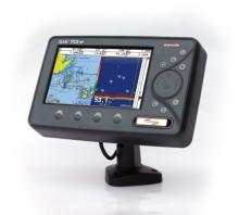
ekran 7" SW 701i
rozdz. 800 X 480 antena wewnętrzna
SEIWA SW 701i
- Ekran 7"; LCD , poziomy
- mapa widoczna w słońcu
- Rozdzielczość 800 X 480
- 50 tras z 500 punktami
- 5 portów NMEA
- mała szerokość obudowy
- uchwyt szybkomocujący
- 2 lata gwarancji
- wodoodporna obudowa
- możliwość podłączenia echosondy
- antena GPS wewnętrzna
MENU I INSTRUKCJA W JĘZYKU POLSKIM
Product Description
SW701x Series comes with internal or external GPS, with high resolution display 800x480 pixel WVGA (Wide Screen). It is extremely fast responsive, completely waterproof (IP67), and can be flush mount (completely built in, on a level with the helm) or bracket mounted.
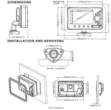
The new revolutionary quick disconnect adjustable bracket can be both tilted and rotated, matching all possible positioning and installation needs, plus offering the easiest removal solution.
SW701x Series can be transformed into a radar when connected to one of the Seiwa radar scanners.
SW701x Series supports advanced features such as free downloadable weather overlays and forecasts, 3D perspective view, HD photos, tidal heights and currents as well as the Guardian Alarm which checks your route for potential grounding issues.
If SW701x Series is combined with SEIWA Black Box Fish Finder (50/200Khz, 100W), you can choose from a full screen sounder display or split screen sounder/chart plotter, and can be coupled with various kinds of plastic stern thru hull transducers, or in hull transducers, or bronze thru hull transducers: the unit works with Xid AIRMAR transducers.
Soft Keys are available to guarantee maximum efficiency and easiness of use, which change function depending upon the current display with an easy key label prompted on the screen.
User friendly state-of-the-art software with outstanding graphics and cutting edge functions such as 'Grounding Alarm', Anchor Alarm, Weather Forecast, Multilanguage.
SW701x Series is compatible with DSC and AIS equipments and is equiped with WAAS/EGNOS/MSAS GPS active antenna.
The units are compatible with C-MAP by Jeppesen cartography, using SD cartridges.
Top page Request more info
Summary of Features
Worldwide Built-in Cartography showing detail up to 2.0 NM
C-MAP by Jeppesen MAX charts compatible
Object-oriented chart system with enhanced functionality including:
Guardian alarm, Safety Status Bar, Safe Route Checking
Perspective View
Satellite Image Coverage (on worldwide background)
Turbo and Smooth Zoom
Multilanguage
Enhanced Port Information database
Tides & Currents data
Photos & Diagrams
Automatic Information on all chart objects and User Points
Find function for Ports Services, Ports By Name, Ports By Distance, Tide Stations, Wrecks, Obstructions, Lakes Information
10,000 User Points: Waypoints/Marks
Waypoints).
10,000 Track Points
Tracks 5
50 Routes
User Points Icons 16
Create, Move, Insert, Edit, Delete, Send, Receive Waypoint
Create, Move, Edit, Delete, Send, Receive Mark/Event
Navigation to Goto
Create, Save, Name, Edit, Delete, Send, Receive or Follow a Route
Route Data Report and User Points (Marks/Waypoints) List pages
Display vessel's position, direction and Track
Man OverBoard (MOB) to navigate back to a missing person or object
Weather Service capability
Range & Bearing function
Simulation Mode with cursor control
Top page Request more info
Functions
BBFF compatible
Radar compatible
AIS compatible
DSC compatible
WAAS/EGNOS/MSAS compatible
MOB (Man Over Board)
Time to Destination
Distance to Destination
Selectable track color
Compass Calibration
Navigation Info
Automatic Info on cartographic objects
Simulation Mode
Top page Request more info
Key pages
Positional information from GPS
Depth Graph Page (Split & Full)
Navigation Data page
3D Road page
GPS Status page
Wind Data page
Gauges page
DSC Log and DSC Directory pages
AIS Report List page
Fish Finder Page
Radar Page
User Points List Page
Top page Request more info
Alarms Handling
Auto Off
Arrival Alarm
XTE Alarm
Anchor Alarm
Depth Alarm
HDOP Alarm
Heading Alarm
Grounding Alarm
Grounding Depth Limit Alarm
Grounding Alarm Range
External Alarm
Top page Request more info
Technical specifications
Microprocessor: ARM9 S32442MSP3 300MHz
Display: 7 " TFT LCD Colour
Sunlight viewable Display
Resolution: 800x480
Power consumption: 18W (1.5 A @ 12 V)
Supply Voltage: 10-35 Vdc
Cartridge slots: 1 x SD-Card
GPS Antenna: SW701i internal, SW701e external with cable
Operating temperature: 0-55 °C
Connectors:
In/Out NMEA ports: 5 x Nmea 0183
Video Input: 1 PAL or NTSC composite video
For SW701e, the GPS connection is made through the quick disconnect bracket
Power In/Out: 10 pin
Nie jest to oferta w rozumieniu prawa handlowego, a podane wartości są jedynie orientacyjne.
Prosimy o każdorazowe potwierdzenie dostępności i ceny
|


2024/03/25 Godziny otwarcia sklepu:
PON do PT. __ 10 do 17
SOB. _______ 10 do 14
NDZ. _______ nieczynne
SKLEP CZYNNY CAŁY ROK !  2024/03/25 Sobota 30 MARZEC Nieczynne
Poniedziałek 1 KWIECIEŃ Nieczynne
2024/03/25 numer tel.  2024/01/02 OTWARTE
2/01/2024 od 10 do 17
3/01/2024 od 10 do 17
4/01/2024 od 10 do 17
5/01/2024 od 10 do 17
6/01/2024 SOBOTA Zamknięte
2023/12/20
23/12/2023
SOBOTA
Zamknięte
2023/08/03
05/08/2023
SOBOTA
Zamknięte
2022/12/30
31.12.2022
otwarte od 10 do 14
2021/06/01 03/06/2021 nieczynne
04/06/2021 otwarte od 10 do 17
05/06/2021 otware od 10 do 14
2019/12/30 30 Grudnia od 10 do 17
31 Grudnia od 10 do 14
1 stycznia nieczynne
2019/11/07 9 listopada otwarte normalnie od 10 do 14
10 listopada nieczynne
11 listopada nieczynne
2019/11/06 Książka ASTRONAWIGACJA DLA ŻEGLARZY autorstwa kapitana Jana Ludwiga
2019/11/05 UWAGA !!!
Nasz formularz kontaktowy nie działa prawidłowo, Nie dołacza się adres e/mail nadawcy. Prosimy podawać aders w treści wiadomości  2015/02/15 2013/03/22 Ta strona używa cookie. Dowiedz się więcej o celu ich używania i zmianie ustawień cookie w przeglądarce. Korzystając ze strony wyrażasz zgodę na używanie cookie, zgodnie z aktualnymi ustawieniami przeglądarki. 2012/04/12 Nowy ciekawy obszar wide z C/MAP
Mapa Bałtyku w rozsądnej cenie. 2012/01/09 Walcujemy końcówki na linach stalowych
Na miejscu mamy maszynę do lin o średnicy:
2,5 mm
3 mm
4 mm
5 mm
6 mm
8 mm
Inne większe rozmiary czas oczekiwania po zleceniu może wynieść 1/2 dni robocze, ale wymaga potwierdzenia. (walcujemy tylko na sprawdzonych materiałach)
2010/12/23  Ronstan 2010/03/02 Naklejka z Międzynarowodym Kodem Sygnałowym MKS dostępna 2010/02/25 Jak szyć szybko ręcznie żagiel?
Za pomocą urządzenia Speedy Stitcher Sewing Awl Kit
2010/01/15 Zapraszamy do kontaktu przez SKYPE
Skype me: clipper_gdynia (Brak mikrofonu tylko rozmowa tekstowa )
2008/11/26 Locja 502 Wybrzeża Polskiego dostępna. Zapraszamy do składania zamówień. 2008/03/18 zobacz jak dojechać do nas
Google Maps
2007/03/05 Finał THE TALL SHIPS' RACE 2007 w tym roku w Szczecinie więcej szczegółów na stronie www.szczecin2007.pl2007/01/15 TOWAR WYSYŁAMY
/ KURIEREM (dowolnie wybranym)
/ POCZTĄ POLSKĄ 2005/12/09 Uwaga Al.Zjednoczenia zmieniła nazwe na Al.Jana Pawła II
2005/09/08 Nie masz co zrobić z zużytymi bateriami ? Nie wrzucaj ich do kosza. Przynieś je do nas i wrzuć do specjalnej puszki. www.reba.pl www.kzg.pl2004/07/13 Bądźmy ekologiczni chrońmy środowisko... 2004/06/15 Sklep żeglarski CLIPPER startuje z nową witryną internetową! Mamy nadzieję, że nowa strona spodoba się Państwu i z ochotą będziecie na nią powracać. |


 tel.(0-58) 661-60-85, e-mail:
  ABY ZAMÓWIĆ TEN PRODUKT ZADZWOŃ LUB WYŚLIJ E-MAIL
 drukuj